Featured post

Welcome to the Audley Rural Parish Council website

Here you will find information about the Parish Council, the Councillors, the area it covers, Council meetings, minutes and agendas.

The Parish of Audley is the largest in area in the District of Newcastle-under-Lyme, covering some 2717 hectares.  The Parish has a population of around 7988, and comprises 7 distinctly separate villages and many small hamlets.  The council consists of 15 members and has one employee, the Parish Clerk.

For all our latest news, see below. To set up an email subscription, check out the right sidebar.

Adoption of Newcastle Borough Council’s Local Plan – Audley Rural Parish Council letter regarding inclusion of AB2

A letter has been sent today to Mr Gullis, Leader of the Borough Council asking for the recommendation to adopt the Local Plan to be reconsidered.

Please see link to the agenda for the Borough Council Full Council meeting on 8th July :
https://moderngov.newcastle-staffs.gov.uk/ieListDocuments.aspx?CId=152&MId=4558&Ver=4

Please see link to the report recommending adoption of the Borough Council’s Local Plan on 8th July:
https://moderngov.newcastle-staffs.gov.uk/documents/s47516/Local%20Plan%20Adoption%20Report.pdf

Letter dated 1st July 2026:

Dear Mr Gullis

Many congratulations on your election as leader of Newcastle Borough Council.

Apologies for the direct approach in light of your conflict of interest, however further to the recent emails, it is appropriate to set out why Audley Rural Parish Council (APRC) has strongly objected to the inclusion of AB2 since it was first identified in the Issues and Options Consultation in 2021, after being a promoted by Indurent to the Borough Council.

ARPC urge you to reconsider your decision to adopt the Local Plan.  Even more so as there is an opportunity to put this on hold, with the requirement to revisit the Local Plan.

This is not a just a case of NIMBYism for a site to fulfil a need for employment in the Newcastle Borough’s Local Plan.  This goes far in excess of any need for the Borough.

The site will see the loss of 80 hectares of prime agricultural Green Belt land  (which is also the Borough’s green belt and farming land) turned over to create 6 “big box” distribution warehouses with 200 HGV lorry park.  This will support an employment need outside of the borough, most likely in other parts of Cheshire East and neighbouring Crewe town.

To put the AB2 size site in context – the site is the size of Audley village and Bignall End village put together.  If it were a residential scheme, we would be looking at approx. 2,400 homes at a low density of 30 dph (less some for green infrastructure) in a Parish consisting of 3,800 homes.  Therefore, whilst ARPC understand the concerns that other areas may have with the ongoing threat of small speculative developments (as do we), ARPC feels that our concerns on the size of development encroaching within our Parish is worthy of proper consideration, as it is excessive development already.

A number of houses directly face the site.  You only have to look at the size of the warehouses and the issues for the residents at Wigan to appreciate the enormous size of warehouses (18 meters)  and what this does to an area as a result of poor decisions taken by Wigan Council.   https://www.bbc.co.uk/news/articles/cwy17pzxy13o

AB2 will consist of 6 “big box” buildings that are between 21- 24 meters in height – in context the same height as Buckingham Palace.  No amount of planning mitigations and disappearing paint will hide this at the gateway to Newcastle Borough.

This will also weaken the Green Belt in other areas in the Borough, especially with the grey belt implications – as no Green Belt is safe now unless it is adjacent to Kidsgrove or Newcastle Town.

You may also be aware that every time the traffic builds up to the Audley bridge on the A500 on the approach to the M6 J16, drivers, cyclists, horses from the local stables crossing the bridge on Alsager Road fear for their lives.   We have numerous reports of HGV lorries, cars, vans failing to give way and instead crossing at high speeds (60mph has been reported) in front of drivers to rejoin and beat the traffic on the A500.    This last year alone we have seen a huge increase in accidents and near misses caused by an already congested A500/M6 J16.    It is impossible to see how this situation can be improved upon by adding more pressure to the A500/M6 approach and installing traffic lights for vehicles to turn right across the A500.  In fact it is likely that the proposed solution will also see traffic building up on the other side heading towards Stoke, as cars and lorries queue from M6 J16 to turn across the A500 to access the only entrance to the site.

There is already evidence of single lanes and village roads being used to access M6 J16 when traffic builds – this will just push vehicles further away from the A500 onto village roads in all directions including neighbouring Parishes.

For your information attached are ARPC’s objections made on the current Planning Application which has yet to be decided by the Borough Council’s planning committee, and also representations which were made through Barristers at the Local Plan Examination hearings.

In the ARPC’s view this should have been stopped many years ago by the previous administration and the Parish has been let down, however ARPC now urge you to reconsider the recommendation to adopt and to stop this now.

Regards

Cllr D Jervis
Vice Chair Audley Rural Parish Council

AB2 planning application Statement v3 2505006 Final Submitted 260625 – Planning Application
Audley PC Site AB2 Employment V2.3 FINAL issued 01.05.25 – Local Plan Examination
Audley PC Site AB2 Green Belt V2.3 Final issued 01.05.25 – Local Plan Examination

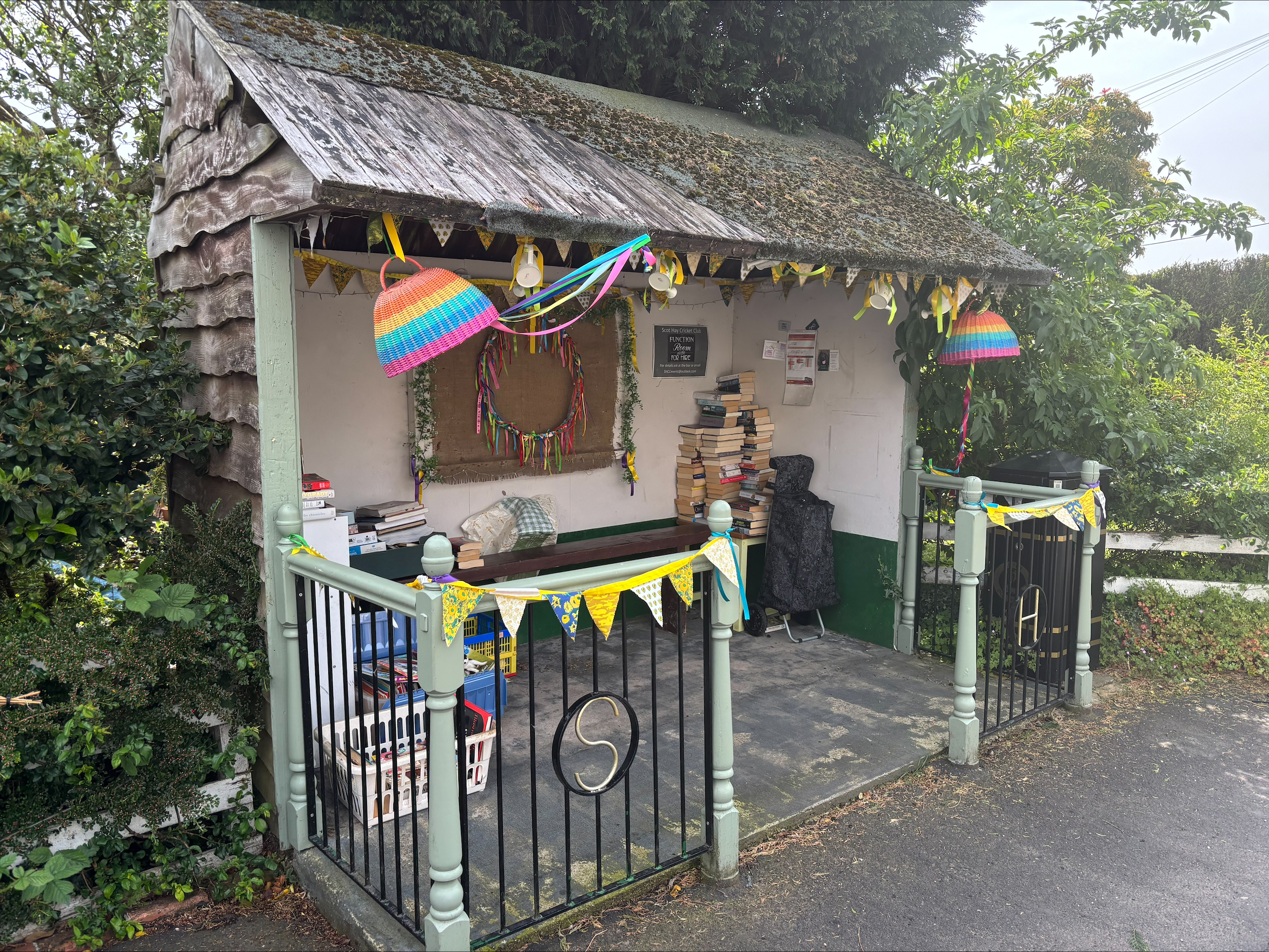
Scot Hay Bus Shelter Closed Mon 22nd to Weds 24th June 2026*

Scot Hay Bus Shelter Closed Mon 22nd to Weds 24th June 2026*
Please note that this bus shelter will be out of use from Monday 22nd June to Weds 24th June 2026 whist the roof is being repaired.
D&G have been informed to expect to stop short of the shelter to pick up passengers.
Whilst it is not intended to cause any damage to the contents, it would be advisable to remove these please.
Also anything fixed to the roof should also be removed please.
Thank you for your cooperation
*slight date change from earlier post apologies for any inconvenienceImage 1 May 26

Dangerous waters advice – Swimming outdoors

Please see below advice from Staffordshire Police regarding swimming outdoors. Please also note there are ‘No Swimming‘ signs at the entrance and on the island at Leddys Field pond for good reason, and also you should not swim at Bateswood or Cloggers Pool due to unseen dangers.
Please click this link to access the webpage for the advice https://www.neighbourhoodalert.co.uk/Alerts/A/446750


Message Sent By Hannah Chaplin
(Staffordshire Police PCSO, Newcastle under Lyme)

Dangerous waters

As temperatures rise, swimming outdoors can seem like the perfect way to cool down. But swimming in open water — like rivers, lakes, reservoirs are extremely dangerous.

The Child Death Review Team has reported that teenagers are proportionately more likely to lose their lives to drowning
when temperatures exceed 25C, so it’s vital that everyone knows the risks associated with open water swimming.

If you work with children and families, or if you care for any children, make sure you’re sharing guidance on how to stay safe with them.

Know the Risk Factors:

– Cold Water Shock
Even on a hot day, open water can be cold enough to cause a sudden, involuntary gasp for air, muscle cramps, and panic. This reaction, known as cold water shock, can quickly overwhelm even confident swimmers.

– Strong Currents
Fast-moving water, tides, or undercurrents can easily sweep swimmers away — often faster than they can react or escape. These forces are unpredictable and can be fatal.

– Hidden Hazards
Open water often hides submerged rocks, rubbish, sudden drops, tangled weeds, and other unseen dangers. These can cause injury, entrapment, or panic.

Advice for Parents and Young People:
Avoid swimming in open water unless it’s a designated, lifeguarded area.

Talk openly to young people about the dangers and encourage them to think before entering the water.

Encourage safe alternatives like swimming pools or organized water activities with supervision.

Staying safe doesn’t mean missing out on fun — it means making informed, smart choices when it comes to water.

Extra security advice from Staffordshire Police following recent thefts

Please click here to view the post at https://www.neighbourhoodalert.co.uk/Alerts/A/445980

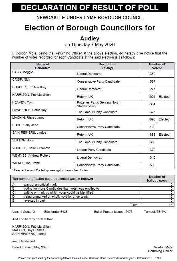
Elections on 7th May 2026 for the Borough Councillor seats within the borough of Newcastle-under-Lyme

You can find the nominations for the Audley Borough Council ward here Audley BC Nominations (PDF)

  • Anyone who is not registered to vote can register online (deadline now passed for these elections which was 20th April)
  • Photo ID is needed at the polling station. Find out more here.

Links to detail of all candidates standing in the borough council election can be found here.

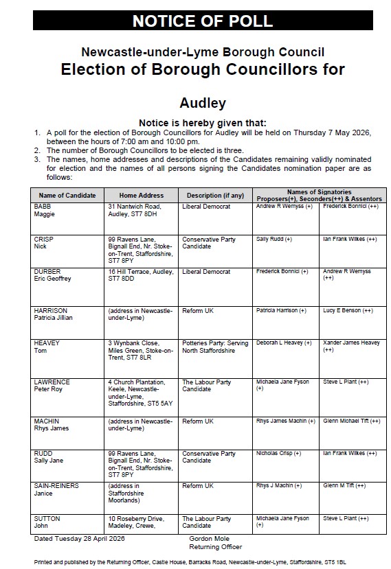
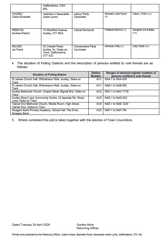
Please see below Notice of Poll and Situation of Polling Stations – Newcastle-under-Lyme Borough Council Election

Polling stations NOP BC

Polling stations NOP BC page2

BC candidates

You can find the nominations for the Audley Borough Council ward here Audley BC Nominations (PDF)

Elections on 7th May 2026 for the Borough Councillor seats within the borough of Newcastle-under-Lyme

You can find the nominations for the Audley Ward of Newcastle under Lyme Borough Council here Audley BC Nominations (PDF)

BC candidates

Links to detail of all candidates standing in the Newcastle Borough Council election can be found here.

Voting in the 7th May 2026 Elections

  • The deadline to register to vote is 11.59pm Monday, April 20
  • The deadline to apply for a postal vote is 5pm Tuesday, April 21
  • If you wish to nominate someone else to vote for you at the polling station, then that proxy vote must be applied for by 5pm Tuesday, April 28
  • Anyone who is not registered to vote can register online.
  • Photo ID is needed at the polling station. Find out more here.

Poster about how to register to vote poster Electoral commission May 2026 garden please click on the pdf for more details

Please click here to find out how to register to vote in the next Local Elections (Parish and Borough) Thurs 7th May 2026


Local Elections – Parish and Borough 7th May 2026

This year, all Borough and Town/Parish elections are taking place, meaning that every current
councillor will retire and must reapply if they wish to stand again. There are 44 Borough seats and 122 Parish seats to be filled across the Borough. In 2022, there were 103 nominations for the Borough seats and 120 for the Parish seats. Of the 22 parish wards, only 5 were contested in 2022.

Audley Parish Council – Parish Wards (see below link to map of wards)
– Audley (Audley): 4 seats
– Audley (Bignall End): 6 seats
– Audley (Halmerend): 5 seats

Following the nominations deadline of 9th April 2026, the outcome was that the 3 Parish wards were uncontested – which means there were only enough candidates to fill the above seats and as a result did not require a contested vote on 7th May 2026.   All candidates have been elected accordingly following due process. The results are below:

Audley Parish Council -_Halmer End ward_- uncontested election results (PDF)
Audley Parish Council – Bignall_End ward – uncontested election (PDF)
Audley Parish Council –  Audley ward – uncontested election (PDF)

There is one vacancy for Halmer End which will be co-opted in May.  Applications will be invited in due course.

Details of all the town and parish council elections can be found here.

Please click here to view a map of the Parish Wards – Audley, Halmer End and Bignall End

Work taking place at Halmer End Play area – Tuesday 3rd Feb to Friday 6th Feb 2026

Work is taking place at Halmer End Play area, off Wesley Place/Harrison Close – from Tuesday 3rd Feb until Friday 6th Feb 2026

Please be aware that from Tuesday 3rd Feb 2026 onwards until Friday 6th Feb 2026 there will be contractors at Halmer End Play area (Horticon Ltd) who are replacing worn out grass mats on one of the pieces of play equipment.
H&S plans are in place and will be adhered to, but if you visit the site please be aware and avoid the cordoned off areas where the work is taking place.
The CCTV cameras are on site, so we would like to remind anyone not to interfere with safety fencing etc left on site.

Thank you to Halmer End CIC (Stute) for their help also.

Screenshot 2026 02 02 165222

**CAR PARK NOW OPEN (CHURCH STREET NEXT TO HERON FOODS AND TESCO) TUES 27TH JAN **

**CAR PARK NOW OPEN (CHURCH STREET NEXT TO HERON FOODS AND TESCO) TUES 27TH JAN **

Following the earlier message, we have been able to complete the investigation works and drainage survey, and have now reopened the car park.

We have also carried out an interim tidy up. Please note that where the trial pits have been dug there is soft ground that will take a while to settle – so a contractor will return at a later date to top up the ground and level again. The main trial pit at the centre of the site (near the lower end) has barriers around it due to a mound left as there was still some water present when it was backfilled. Please avoid this area and please do not move the barriers.

Thank you to Rob Elliot Ltd, S Hough and S Till.

Apologies for the inconvenience caused while the work was underway and thank you again for your understanding.

Closure of Car Park Church Street (by Tesco/Heron Foods) – Tues 27th and Weds 28th Jan

**UPDATE ON CURRENT CAR PARK (CHURCH STREET) CLOSURE ON TUES 27TH JAN – POTENTIAL FOR FURTHER CLOSURE ON WEDS 28TH JAN 2026**

Thank you for your co-operation and help to keep the car park free of vehicles.

We have been able to carry out 4 trial pits to provide the required information for the upcoming planning application to redevelop the car park. However the ongoing weather conditions are impacting on the soakaway test. If the rain continues to be heavier than originally forecast, then it may impact on the measurements needed to calculate the drainage solutions. The test involves monitoring the amount of time it takes for the water to dissipate in the trial pits – which will inform the design. As the ground is made up of clay this is not a quick process.

Whilst we do not want to keep the car park closed longer than necessary, there is a chance we may need to keep it closed overnight until tomorrow during the day. It is important that the drainage solution is correctly designed and specified to avoid the ongoing issues we have. Apologies for the inconvenience and thank you for your understanding.

No photo description available.

Actions for A500/Alsager Road junction

Actions for A500/Alsager Road junction

The Parish Council is in regular direct contact with officers at National Highways, who are responsible for the A500 and the slip road, to campaign for action following the previous and ongoing accidents.

We are aware that there have been two further accidents reported since the temporary signs were installed, plus regular near misses due to drivers seeking to avoid congestion. This information is passed onto National Highways, please continue to report any near misses.

We have received the following update from National Highways, and want to keep you informed given the ongoing concerns:

Upgraded signing on slip road
The works are committed, and National Highways are aiming to complete the upgrade by 31 March 2026.

Collision Data
National Highways will continue to analyse the collision data to establish the primary causation factors as and when Staffordshire Police release their reports to Staffordshire County Council.

M6 J16
The anecdotal evidence of increased usage of the slip roads at the A500/Alsager Road junction (westbound) is to queue jump congestion on the A500. Traffic signal engineers have reviewed the timings of the signals at M6 J16 and have concluded the signals are working as intended (no faults identified). The problem is down to traffic growth and an ageing asset. The M6 J16 junction layout simply cannot accommodate 2026 and beyond vehicle capacity as it exceeds the current design geometry. Unfortunately, the junction is not a priority for future road investment in the short term.

Alsager Road
The local road is managed by Staffordshire County Council (SCC) who have agreed to review road safety. SCC will forward their conclusions including any actions they are able to deliver in due course.

In vehicle SAT NAV Technology
Examples of google desktop sat nav tool prioritising the slip road rather than staying on the A500 have been raised at partnership meetings with the leading suppliers of sat nav technology. The response is they will investigate but have made it clear motorists have a duty to drive within the law and follow guidance contained within the Highway Code. In car technology is provided to improve the driver experience but the driver is ultimately responsible for ensuring they continue to drive with due care and attention.

The Police have also advised they will carry out sat nav tests using their vehicles. Report will be provided in due course.

Continued monitoring
National Highways Inspectors will continue to check the junction as part of their weekly route safety checks. Any safety critical issues identified such as fading road markings or vegetation compromising visibility will be defected and fixed in line with the contractual timelines.

Camera survey
A survey has been completed. Results are awaited of any findings of interest.

Temporary signing
Temporary signing to remain in place until the works to upgrade the permanent signing has been completed.

Contact details for National Highways:

https:/www.nationalhighways.co.uk
Customer Service No.: 0300 123 5000 or email info@nationalhighways.co.uk

Planting of Sakura Cherry Trees at Minnie Pit Heritage Site Thurs 22nd Jan

Planting of Sakura Cherry Trees at Minnie Pit Heritage Site Thurs 22nd Jan

Header

The Parish Council in collaboration with the Minnie Pit Heritage Site committee have been successful in securing 4 trees from the Sakura Cherry Tree Project.
The 4 trees being planted at Minnie Pit Heritage Site are some of the over 8,000 Japanese cherry trees – or Sakura in Japanese – given to the UK by Japan, and planted across the country in parks, gardens and schools to celebrate Japan’s relationship with the UK.
The project is a legacy from the Japan-UK Season of Culture 2019-2021, which aimed to showcase Japan’s multifaceted attractions in the UK. The gift of these trees enables people to learn more about Japan, its culture and traditions. It is the intention of this project to plant across the whole of the United Kingdom so that each spring there is a wave of cherry blossom across the country.
The Sakura Cherry Trees will be distributed to over 1,000 sites in all four countries of the UK from St Ives to Aberdeen to Londonderry, Cardiff and several of London’s biggest parks. The project was formally launched with a planting ceremony at The Regent’s Park attended by HRH The Duke of Gloucester, the then Japanese Ambassador Yasumasa Nagamine, Joint Chairman of the Sakura Cherry Tree Project Keisaku Sandy Sano and local school children in 2019.
To date, trees have been planted in all the counties of England and Wales, and planting continues in Scotland. Trees have been planted in Northern Ireland, the Orkneys, Tresco in the Scilly Isles, the Isle of Wight and the Isle of Man, and planting will continue for the next two years, completing in 2027.

If you would like to be present at the planting, please email clerk@audleyparishcouncil.gov.uk – we are hoping for Thursday 22nd January 26, but it is weather dependant.

Logo project 2 Logo project

Audley Methodist Church car park – closure one day Tues 27th Jan

Audley Methodist Church Car Park (next to Tesco/Heron Foods) – closure for one day on Tues 27th January 2026

The closure of the car park is now planned for Tuesday 27th January 2026 (one day) for the trial pits and drainage survey to take place from 8.30am onwards.

Please do not park on the car park as your vehicle will be at risk of damage. It may also hinder the progress of the survey, which is required to inform a planning application to improve the car park overall.

Apologies in advance for any inconvenience and thank you for your co-operation.

No photo description available.

Audley Methodist Church Car park – planned closure (one day)

Audley Methodist Church Car Park (next to Tesco/Heron Foods) – update on provisional closure on Tues 13th January 2026

The closure of the car park provisionally planned for Tuesday 13th January 2026 (one day) for the trial pits and drainage survey has been postponed. A new date is being arranged, potentially for w/c 26th January and this will be notified to all, as soon as it is confirmed.

Apologies in advance for any inconvenience.

No photo description available.

New Parish Councillors (3)

We would like to extend a very warm welcome to Neil Ginnis (Audley Ward), Sarah Williams (Halmer End Ward) and Chris Griffiths (Halmer End Ward), who have recently joined the Parish Council 👋✨

Following the appropriate due process, their appointments were formally agreed at the last Council meeting held on 18 December 2025. All three individuals bring their own individual valuable experience, knowledge and enthusiasm to the Parish Council, and we are delighted to welcome their contribution and involvement 🤝🌟
The next Borough, Parish and Town Council elections will take place on 7 May 2026 🗳️. In early spring, Newcastle Borough Council will begin the nominations process to invite candidates to stand for election, and further information will be shared in due course.

If you are interested in standing as an elected member and helping to shape your local community, you can find further guidance here:

Audley Rural Parish Council’s Views on the Strategic Employment site (AB2) in the Local Plan (NBC Local Plan Main Modifications Consultation Ends 17 December)

Audley Rural Parish Council’s Views on the Strategic Employment site (AB2) in the Local Plan
(NBC Local Plan Main Modifications Consultation Ends 17 December)

What is AB2?

AB2 is a proposed Strategic Employment site in the Newcastle-under-Lyme Local Plan. It covers almost 80 hectares of agricultural land and open countryside currently within the Parish and Borough’s Green Belt, located near Junction 16 of the M6 and bordering the A500, Park Lane, Moat Lane, and Barthomley Road.  For context, the total site area is comparable in size to the combined villages of Audley and Bignall End.

In addition to the Local Plan, a planning application has been submitted by the developer for the AB2 site which includes:

  • Six “Big Box” logistics warehouses
  • A 200-space HGV lorry park
  • A new left-turn access for A500 westbound traffic
  • A traffic-light controlled right turn for vehicles approaching from the Junction 16 of the M6
  • Creation of 2,500 to 3,570 jobs
  • Green Infrastructure

As a Strategic Employment site, AB2 will provide jobs for Newcastle-under-Lyme, but also the wider areas including Cheshire East and Stoke-on-Trent. Cheshire East Council has formally objected to the allocation in the Local Plan stating: “Site AB2 is adjacent to the borough boundary and is slightly closer to the centre of Crewe than it is to the centre of Newcastle-under-Lyme (and much closer to the centre of Alsager). There are concerns over the impacts that the plan may have on Cheshire East, for example in terms of housing demand, infrastructure requirements and travel patterns”.

Parish Council considerations

Since 2021, the Parish Council has objected to the AB2 site allocation.  At the Local Plan Examination hearings in May and June 2025, the Parish Council presented detailed representations using legal expertise.  Key considerations included:

  • Green Belt designation: National planning policy requires “exceptional circumstances” to alter Green Belt boundaries, and the Parish Council sought clarity on how these tests have been met.
  • Environmental role of the land: The site provides a buffer between nearby settlements and major roads.
  • Local impacts: Potential issues include noise, light pollution, air quality, increased traffic through local roads, and additional pressure on infrastructure and services.

Traffic and A500 slip-road safety

The concerns raised by the local residents regarding transport and road-safety conditions around the A500 slip road, which serves the area, have been raised within the representations.  Increases in traffic collisions at the Audley/Alsager Road slip-road exits, linked to congestion on the A500, reinforce the validity of these concerns.  The Parish Council has requested that these existing conditions be carefully considered by the Planning Inspector when assessing the site’s suitability.  The Parish Council has also asked for clarification on how additional vehicle movements—including HGV traffic associated with the proposed development—would be managed, and what measures may be required to ensure safe access to and from the site.

Next steps

Further representations will be made in response to this last consultation which ends 17th December 2025.